Sights2see.com

Vincennes forest

Bois de Vincennes
  • 3.00

  • Rate it!

Address: Route de la Pyramide, 75012 Paris
Contributed by: 
07-24-2018
Rating
Outstanding
Excellent
1
Very good
Good
1
Fair

Ranked #124 of 144 in France

Ranked #56 of 61 in Ile-de-France

Ranked #49 of 53 in Paris

No video yet

From Wikipedia, the free encyclopedia
The Temple of Love on Lac Daumesnil in the Bois de Vincennes

Bois de Vincennes

Coordinates: 48°49′41.05″N 2°25′58.50″E / 48.8280694°N 2.4329167°E / 48.8280694; 2.4329167

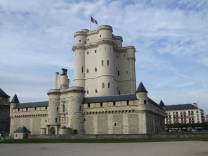
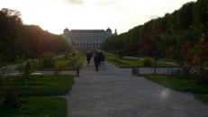
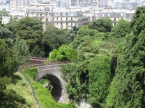
The Bois de Vincennes (French pronunciation: ​[bwɑ.d(ə).vɛ̃.sɛn]), located on the eastern edge of Paris, is the largest public park in the city. It was created between 1855 and 1866 by the Emperor Napoleon III.

The park is next to the Château de Vincennes, a former residence of the Kings of France. It contains an English landscape garden with four lakes; a zoo; an arboretum; a botanical garden; a hippodrome or horse-racing track; a velodrome for bicycle races; and the campus of the French national institute of sports and physical...

Read more at Wikipedia
Reviews (0)
Information missing or incorrect? Please let us know
Klook.com
Attractions which are close by:

3 km / 2 mi

images images images images

6 km / 4 mi

images images images

7 km / 5 mi

images images images images

7 km / 5 mi

images images images

8 km / 5 mi

images images images images

8 km / 5 mi

images images images

8 km / 5 mi

images images

9 km / 5 mi

images images images images

9 km / 5 mi

images images images images

9 km / 5 mi

images images images images

9 km / 5 mi

images images images images

9 km / 6 mi

images images images images

9 km / 6 mi

images images images images

9 km / 6 mi

images images images images

9 km / 6 mi

images images images images

9 km / 6 mi

images images images images

9 km / 6 mi

images images images images

10 km / 6 mi

images images images images

10 km / 6 mi

images images images images