

No video yet


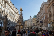
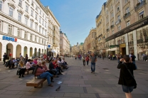
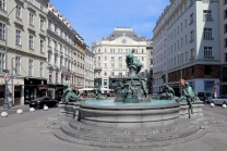
Graben, Vienna
The Graben is one of the most famous streets in Vienna's first district, the city centre. It begins at Stock-im-Eisen-Platz next to the Palais Equitable and ends at the junction of Kohlmarkt and Tuchlauben. Another street in the first district is called Tiefer Graben (deep ditch). It is crossed by Wipplinger Straße by means of the Hohe Brücke, a bridge about ten metres above street level.
History
Origins
The Graben traces its origin back to the old Roman encampment of Vindobona. The south-western wall of the settlement extended along the length of the present-day Graben and Naglergasse; before the wall lay a trench (Graben). This trench still stood in front of the medieval city walls. At the end of the 12th century, the city was enlarged by the Babenberg Dukes, using the ransom money for Richard the Lionheart. At this time the trench was filled in and levelled. The Graben thereby became one of the first residential streets in the new section of the city. In this area of the city large unbuilt areas were still available, which probably contributed to the maintenance of the name "Graben" up until the present day.
Middle Ages
The planned character of the city extension is still visible in the differing characters of the building patterns to the north and to the south of the Graben. The building pattern on the north side (that of the old city) has remained irregular to this day, and only one, narrow side-street opens off the Graben to...


.JPG)