No video yet


Stevns Klint
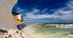
Stevns Klint is a white chalk cliff located some 6 km (3.7 mi) southeast of Store Heddinge on the Danish island of Zealand. Stretching 17 km (11 mi) along the coast, it is of geological importance as one of the best exposed Cretaceous-Tertiary (K/T) boundaries in the world. Subject to frequent erosion, the cliff rises to a height of up to 40 m (130 ft). The cliffs are a UNESCO site.
Geology
The cliff reveals sections from the uppermost part of the Maastrichtian stage (72 to 66 million years ago) and from the lowermost part of the Danian stage (66 to 62 million years ago). The dark layer of Fiskeler, mainly five to ten centimeters thick, clearly marks the Cretaceous-Paleogene boundary. The Fiskeler is enriched in iridium, a fact used as an argument for the Alvarez hypothesis that the worldwide Cretaceous–Paleogene mass extinction was caused by the impact of an asteroid. The layers can also be seen deep in the tunnels of Stevnsfortet, a cold-war fortress constructed in 1953. The bryozoa chalk in the cliff is highly shock resistant to both conventional and nuclear weapons.
Cold War museum
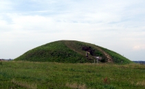
In 2008 Cold War Museum Stevns Fortress opened to the public. It features a large exhibition of military equipment and a 1.5-hour guided tour in the large underground system of the fortress. The underground system of the fortress features 1.6 kilometres (0.99 mi) of tunnels, living quarters and command centers, including a hospital and even a chapel. There are also two ammunition depots for its two 15 centimetres (5.9 in) cannons. The tunnels are 18–20 metres (59–66 ft) below the surface, dug deep into the chalk of Stevns. The top secret fortress was built in 1953 and remained operational until 2000.
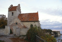
Højerup Church
The old Højerup Church (Højerup Gamle Kirke) which stands at the top of the cliff dates from the year 1200. As a result of erosion, a landslide in 1928 caused the chancel to collapse and fall to the shore below. The cliff can be accessed via steps from the church. A new church completed in 1913 is located 300 m (980 ft) back from the cliff.
UNESCO listing
On 23 June...