San Andrés, El Salvador
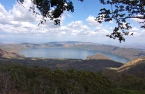
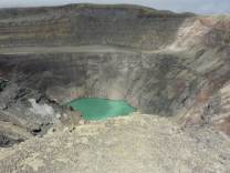
San Andrés (formerly known as Campana San Andrés) is a pre-Columbian site in El Salvador, whose occupation began around the year 900 BC as an agricultural town in the valley of Zapotitán in the department of La Libertad. This early establishment was vacated by the year 250 because of the enormous eruption of the caldera of Lago Ilopango, and was occupied again in the 5th Century, along with many other sites in the valley of Zapotitán. Between 600 and 900 AD, San Andrés was the capital of a Maya polity with supremacy over the other establishments of Valle de Zapotitán.
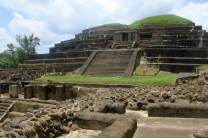
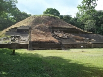
The residential area has not yet been well studied. The investigations and excavations in San Andrés have been primarily of the political-ceremonial center and have revealed that it was divided into the South Seat (from which they governed) and the North Seat. In the year 600, the South Seat was filled with adobe (leaving a tunnel leading to the original seat) to construct the Acropolis, which contains ceremonial and political structures. In the ends to the South and East of the Acropolis are pyramids or structures: 1 (the main pyramid), 2, 3 and 4. In the North ends and the west are a series of rooms where the governors lived (the last palaces of San Andrés) of which two have been reconstructed. To the south of the Acropolis lies structure 7, another ceremonial structure. In the North seat, or Great Seat, is the pyramid or structure 5 (called "La...