No video yet


Poulnabrone dolmen
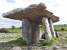
Dolmen in the Burren, Co. Clare, IrelandPoulnabrone dolmen (Poll na mBrón in Irish) is an unusually large dolmen or portal tomb located in the Burren, County Clare, Ireland. Situated on one of the most desolate and highest points of the region, it comprises three standing portal stones supporting a heavy horizontal capstone, and dates to the Neolithic period, probably between 4200 BC and 2900 BC. It the best known and most widely photographed of the approximately 172 dolmens in Ireland.
The karst setting has been formed from limestone laid down around 350 million years ago. The dolmen was built by Neolithic farmers, who chose the location either for ritual, as a territorial marker, or as a collective burial site. What remains today is only the "stone skeleton" of the original monument; originally it would have been covered with soil, and its flagstone capped by a cairn.
When the site was excavated in 1986 and again in 1988, around 33 human remains, including those of adults, children (and the remains of a much later Bronze Age infant) were found buried underneath it, along with various stone and bone objects that would have been placed with them at the time of interment. Both the human remains and the burial objects date to between 3800 BC and 3200 BC.
Name
Poulnabrone is translated from Poll na mBrón in Irish. "Brone" is derived from the Irish bró, meaning quern, so the name appears to mean "Hole of the Quernstones". It is sometimes wrongly translated as "Hole of Sorrows".
Location and purpose
Poulnabrone dolmen is situated in a rocky and unblemished field in the remote and high altitude townland of Poulnabrone, Kilcorney, close to the R480 road, 8 km south of Ballyvaughan, in what is now a national park. Its location would have been difficult of access at the time it was built, and it was probably used a centre for ritual until well into the Bronze Age, with evidence that it was in use even into the early mediaeval Celtic era. It may have served also as a territorial marker in the Neolithic landscape, in a significant position widely visible from all around and...