


Teotihuacan
Coordinates: 19°41′33″N 98°50′37.68″W / 19.69250°N 98.8438000°W / 19.69250; -98.8438000
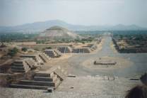
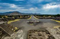
Teotihuacan Location in Greater Mexico CityTeotihuacan /teɪˌoʊtiːwəˈkɑːn/, also written Teotihuacán (Spanish pronunciation: [teotiwa'kan] ( listen), modern Nahuatl pronunciation (help·info)), is an ancient Mesoamerican city located in a sub-valley of the Valley of Mexico, located in the State of Mexico 40 kilometres (25 mi) northeast of modern-day Mexico City, known today as the site of many of the most architecturally significant Mesoamerican pyramids built in the pre-Columbian Americas.
At its zenith, perhaps in the first half of the 1st millennium AD, Teotihuacan was the largest city in the pre-Columbian Americas, with a population estimated at 125,000 or more, making it at least the sixth largest city in the world during its epoch.
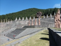
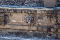
Apart from the pyramids, Teotihuacan is also anthropologically significant for its complex, multi-family residential compounds; the Avenue of the Dead; and the small portion of its vibrant murals that have been exceptionally well-preserved. Additionally, Teotihuacan exported fine obsidian tools that garnered high prestige and widespread usage throughout Mesoamerica.
The city is thought to have been established around 100 BC, with major monuments continuously under construction until about 250 AD. The city may have lasted until sometime between the 7th and 8th centuries AD, but its major monuments were sacked and systematically burned around 550 AD.
Teotihuacan began as a new religious centre in the...